How does ice cover vary in the Bering Sea from year to year?
Dr. Lyn McNutt
Geophysical Institute
University of Alaska
903 Koyukuk Drive
Fairbanks, AK 99775-7230
Sea ice is one of the most important physical elements of the Bering Sea continental shelf. Sea ice helps define the ecosystem, provides habitat for microorganisms, birds and marine mammals, and affects the migration routes of Arctic marine mammals, such as whales and seabirds. Changes in sea ice are a direct result of the atmosphere interacting with the ocean, especially through changes in wind speed and direction and air temperature. Since the sea ice floats on the surface of the ocean, it moves around in the wind as storms pass by. In the Bering Sea storms usually occur every three to five days. The ice also changes every year due to the paths of the storms. The storm paths, called storm tracks, relate to long-term atmospheric patterns, called teleconnections. These teleconnection patterns range from interannual (several years) to decadal (tens of years). These patterns, in turn, relate to global climate patterns. By studying these local and global connections, scientists can use sea ice in the Bering Sea as an indicator of climate change and its effects on the marine ecosystem.
 |
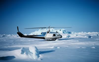
| The Northern Bering Sea in May 1981 |
Sea ice begins forming in the northern Bering Sea as late as November, as the ocean reaches a temperature of -1.7°C, the freezing point for saltwater in this area, and ice may remain into June of the following year. Most of the sea ice forms in the northern portions of the shelf and is then blown southward due to the prevailing north-northeasterly winds. Ice melts at the edge when it moves into an area of water which is warmer than the freezing point. In the Bering Sea, sea ice affects water temperature, salinity and ocean currents. The formation, motion and melting of the ice at the edge play important roles in controlling the heat exchanged between the ocean and the atmosphere, and the amount of salt in the water on the Bering Sea continental shelf. The growth of sea ice also creates cold, salty water, while ice melt makes freshwater. These processes are critical to the physical conditions that influence the way the Bering Sea ecosystem works. In the northern Bering Sea, water enters the Arctic Ocean through Bering Strait, making the Bering Sea the only connection between the Arctic Ocean and the Pacific Ocean.
There are four conditions important to understanding the role of sea ice in the Bering Sea: brine rejection, polynya development, formation of the "cold pool" and variation in ice melt. When the ice forms, not all the salt in the sea water (brine) can be incorporated into the ice as it freezes, and is instead returned to the ocean beneath the ice. This is called brine rejection. By losing this brine, the sea ice becomes less salty, while the underlying water becomes more salty. This changes the way the water currents move under the ice as this cold salty water sinks to the bottom of the sea. As the floating sea ice is blown southward by the wind, it reaches an area of water which is above freezing, where the ice melts rapidly. As the ice melts, it creates a layer of fresher (less salty) water on the surface of the ocean on top of a layer of salty water. The boundary between these two layers is called the halocline. The fresher water on the surface is full of nutrients that are essential to the health and productivity of the ecosystem, especially to the microorganisms called phytoplankton.
 |
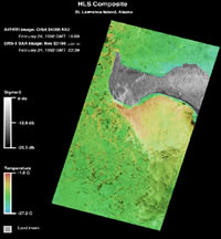
| St. Lawrence Island Polynya. St. Lawrence Island is grey, thicker ice is shown in green, and warmer ice with open water is yellow. |
Brine rejection also occurs in areas called polynyas. Polynyas are areas of open water in the sea ice, which form in the lee of islands and coasts. They are most often created during northerly winds, but may also occur during southerly wind events, and they usually occur in the same places every year. The St. Lawrence Island Polynya is a very large, important polynya that covers hundreds of kilometers. Polynyas work like conveyor belts for ice creation. When a polynya appears, it exposes a large area of water to the cold wind. This water quickly cools and ice forms on the surface. The wind then blows this ice away from the coast, and more water appears so that new ice is constantly being formed and moved around by the wind. All this ice formation creates cold, salty, more dense water through brine rejection, as described above. This dense salty water sets up ocean currents that transport water, and possibly organic matter, to the south and then west of St. Lawrence Island, providing important conditions for creating healthy life on the bottom of the ocean, called the benthos.
Polynyas are also very important feeding areas for marine mammals who live in the Bering Sea all year. Many of these mammals, especially seals and walrus, stay on the sea ice, close to polynyas, where they can feed in the winter. The open water in the polynyas allows them to use the ice as a platform to dive under the water and feed, yet leaves them areas for breathing when they come to the surface.
By forming in the same area every year, and creating cold, dense salty water, the St. Lawrence Island Polynya helps maintain a an area of cold water on the northern Bering Sea shelf called a "cold pool". This colder water then remains throughout the summer, and is often associated with nutrient rich conditions, leaving a "footprint" of productivity under a "cold pool" region. Nutrients are necessary for the benthos, but are also important for development of microorganisms and fish, who live in what is called the pelagic zone, and for predators who feed on benthic and pelagic resources, such as birds, seals, walrus, migrating whales, and man. A second "cold pool" occurs in the middle shelf of the southeastern Bering Sea as a result of thicker sea ice which often remains in this area in late spring. This southern "cold pool" impacts distributions of species of fish such as pollock. These fish are an especially important food source for marine mammals, birds, and man. In fact, pollock from the Bering Sea are often the fish in fish sticks and fish filets that you find in your local supermarket.
When the sea ice melts at the edge in the spring, the fresh water and nutrients in the ice are released onto the surface of the ocean on the Bering Shelf. This water is critical to the development of microorganisms which form the key to the entire ecosystem of the Bering Sea. The measure of the success of these organisms and their contribution to the food chain is called primary productivity. The important relationships of sea ice to primary productivity are: how far south the ice has gone, and when and where does it melt? This brings us back to understanding how sea ice responds to changes in the atmosphere, teleconnections and to global climate patterns.
 |
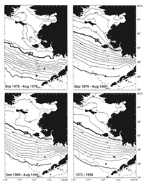
| Maps of sea ice in the Bering Sea seen in different types of atmospheric conditions. |
 |
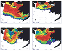
| Four distinct meltback patterns |
There have been three different types of Spring melt in the sea ice cover in the eastern Bering Sea during the last thirty years. This means that three different sea ice conditions have affected the Bering Sea shelf and the ecosystem: 1972-1976 (cold), 1977-1988 (warm) and 1989-2001 (cool). During the cold period, ice extended south to St. Paul Island near the shelf break, and stayed there for a month or more. The climate changed dramatically from cold to warm in the Bering Sea in 1977, and this created changes in the amount of sea ice, air and ocean temperatures, sea level air pressure and surface winds. In the warm period, from 1977-1988, the ice did not reach as far south, and stayed in the southern area 2-4 weeks less than it did in the colder period. In the cool period from 1989 to 2001, sea ice again moved to the south, but it came and went very quickly, often melting before there was enough sunlight for the microorganisms to use the nutrients to create a phytoplankton bloom. Since the cold period ended in 1976, there has not been a return to the extensive sea ice conditions of the early 1970s. If we look at spring melt in May in the more recent years, we see that sea ice ranges from almost none, to heavy ice in the middle of the shelf, to melting in the western shelf and heavy ice in the east. These changes affect the primary productivity, especially phytoplankton blooms, which then affects the entire ecosystem.
Phytoplankton are microscopic plants, also called microflora, that use sunlight and nutrients from the melted sea ice to synthesize carbon through photosynthesis, just like plants on land. Different species of phytoplankton exist in oceans throughout the world. They all play an important role in the exchange of carbon dioxide between the atmosphere and the ocean, and hence, climate change. Zooplankton are microscopic animals, also called microfauna, that feed on phytoplankton. There are several hundred different species of both phytoplankton and zooplankton in the Bering Sea. In the Bering Sea, the phytoplankton that are not consumed directly by the zooplankton sink through the pelagic zone to the benthos at the bottom of the ocean. There they are either eaten by other organisms, or deposited onto the ocean floor.
Phytoplankton blooms in the Bering Sea occur in two different ways: they can start due to ice melt (early bloom), or they can happen later in the season as sunlight increases, even if the ice has melted early (late bloom). The ideal situation is for the bloom to happen when the ice is melting and there is enough sunlight for the phytoplankton to perform photosynthesis. This is not always the case, however, especially due to the changes to the sea ice that have taken place since 1976. If there is an early phytoplankton bloom in cold melt-water, when there are not as many zooplankton, most of the energy from the primary production goes to the benthos. Late blooms happen in warmer water when there is more sunlight, and there are zooplankton present, but there are less phytoplankton due to less nutrients, so most of the energy remains in the water column, the pelagic region. So the timing of the sea ice melt creates early versus late blooms, and this may form two different types of ecosystems in the Bering Sea: benthic versus pelagic.
In the northern Bering Sea ice still remains late in the spring, so most spring phytoplankton blooms are associated with ice melt. However, in the southeastern Bering Sea, the type of bloom depends on the timing of ice retreat, and we know that the sea ice in this area has changed. The amount and type of energy (benthic versus pelagic) created in the Bering Sea ecosystem as a result of the timing and location of the melting sea ice, has a cascading effect on all the fish, mammals and birds in the region.
Many scientists agree that the effects of climate change may first be seen in areas such as the Bering Sea. This makes the Bering Sea, its sea ice, and the ecosystem it supports, very important to understanding how global climate may affect a specific region. The ecosystem in the Bering Sea supports one of the world's richest and most productive fisheries, and is important to the economy of Alaska and the United States. It also has been used by native cultures for centuries. Changes in the sea ice affect the entire ecosystem, but we do not yet know what all the consequences will be. This is especially true if the sea ice conditions observed in the last three decades continue to change as rapidly as seen in recent years.
References:
Books:
Krupnik, I. and D. Jolly (eds), The Earth is Faster Now: Indigenous observations of Arctic Environmental change, ArCUS and Arctic Studies Center, Smithsonian Institution, 356 p. 2002.
Loughlin, T. and K. Ohtani (eds), Dynamics of the Bering Sea, North Pacific Marine Science Organization (PICES), University of Alaska Sea Grant Press, Fairbanks, Alaska, 824 p., 1999.
Articles:
Grebmeier, J.M., and L.W. Cooper (1995). Influence of the St. Lawrence Island Polynya on the Bering Sea benthos. J. Geophys. Res. 100:4439-4460.
Hunt, G.L., P. Stabeno, G. Walters, E. Sinclair, R.D. Brodeur, J.M. Napp, and N.A. Bond. 2002. Climate change and control of the southeastern Bering Sea pelagic ecosystem. Deep-Sea Res. II 49:5821-5853.
Macklin, S.A., Saitoh, S.I., Radchenko, V.I., Napp, J.M., Stabeno, P.J., and McKinnell, S.M. (Editors). 2002. Variability in the Bering Sea Ecosystem. Progress in Oceanography 55(1-2).
Niebauer, H.J., 1998. Variability in Bering Sea ice cover as affected by a regime shift in the north Pacific in the period 1947-96. J. Geophys. Res., 103, 27,717-27,737.
Stabeno, P. J. , N. A. Bond, N. B. Kachel, S. A. Salo, and J. D. Schumacher, On the temporal variability of the physical environment of the south-eastern Being Sea, Fish. Oceanogr., 10:81-98 2001.
Additional Information:
